
I’m a big fan of the River-to-River Greenway trail, a Dakota County project that will complete a regional trail through West St. Paul with a tunnel under Robert Street.
I’ve talked about why I think it’s an awesome idea and I’ve explored some misconceptions about the project.
I’ve also been accused of spreading misinformation about the project. That’s certainly not my intent. I’ve researched the original documents from Dakota County, talked to people involved and done my best to provide clear, honest answers. I’ve pushed to have an open dialogue about this project so we can consider all arguments and make the best decision.
With that in mind, I wanted to address some of the questions I’ve heard about the project:
- What’s it going to cost?
- Why a tunnel and not a bridge?
- Will a tunnel be safe?
- How will construction impact Robert Street?
- What about development?
- Can the River-to-River Greenway cross Robert Street anywhere else?
- What happens when the trail crosses Wentworth Avenue?
- Will the trail really see 140,000 people?
- Why do we say WSP Greenway?
Ready? Let’s dive into the details…
1. What’s it going to cost?
One of the most common questions is cost. The simple answer is that funding is already secured for the project and Dakota County is not asking West St. Paul to contribute any additional funds.
Let’s look at the long answer (again):
There are three options for the tunnel, ranging from $2 million to $3.2 million (according to the December 2016 report). We have funding from multiple sources already lined up:
- $2 million in state funding
- $650,000 in federal funding
- $200,000 in county funding
- 75% of acquisition costs paid by Met Council
That’s a total of $2.85 million in funding, plus 75% of acquisition costs. That completely pays for two of the three options. The county has also said in a factsheet that West St. Paul is not being asked to contribute to the project.
So we should be able to do this project without any additional contribution from West St. Paul.
That includes any cost overruns. Dakota County will cover those, like they did for the Charlton tunnel project.
What about the $1.1 million for the Blockbuster site?
Some people have pointed to the city’s acquisition of the old Blockbuster property as proof that the city will have to pay something for the tunnel. But that’s not quite true either.
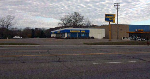
The city paid $1.1 million for the Blockbuster site several years ago:
- $250,000 of that money came from a county CDA grant (the grant application stated that we would put in a crossing of Robert Street on a portion of the site). So West St. Paul actually paid $850,000 for the site.
- The tunnel project will only require one-third of the site, leaving two-thirds open for development. The cost of acquiring the tunnel portion of the site is down to $283,333.
- The Met Council has agreed to pay 75% of acquisition costs. That leaves $70,833.
- The County said in a factsheet that the site is eligible for reimbursement. This means that even the remaining $70,833 can be reimbursed, which should cover the entire cost.
So West St. Paul can be completely reimbursed for the portion of the Blockbuster site used for the tunnel.
What about the lost taxes?
While West St. Paul shouldn’t need to pay anything for the tunnel, there is an opportunity cost. By using a portion of the Blockbuster site for the tunnel, we are losing some land that could be developed and returned to the tax rolls.
But as stated above, we’re talking about one-third of the site. Maybe 80 feet of Robert Street. The other two-thirds of the site can be redeveloped. (And it’s worth noting that the site is an empty lot. No development deal has yet come together. In the most recent proposal, the developer actually asked the city for a $4.5 million subsidy to make the plan feasible. Thankfully we said no.)
Plus, this was the plan all along. When we applied for the CDA grant, we said we would use a portion of the property for a crossing. So this isn’t something new. The City planned to put in a crossing at the Blockbuster site all along.
The real question here is if the benefit of a regional trail outweighs the potential tax benefit of one-third of the Blockbuster site. I’ve pointed elsewhere to how trails raise property taxes and spur development, so I would say the trail is worth it.
What about the feasibility study?
 In 2011 West St. Paul released a feasibility study exploring a separated-grade crossing of Robert Street.
Certainly the cost of this study, which we paid six years ago, is something the city had to pay. So I suppose you could say our total cost over all time is not $0.
But when we talk about the tunnel not costing us anything, we’re talking about additional money the city would need to pay. When I decide to buy a car, I don’t weigh the cost of the copy of Consumer Reports I bought to help me make my decision. That money is spent whether I buy a car or not.
2. Why a tunnel and not a bridge?
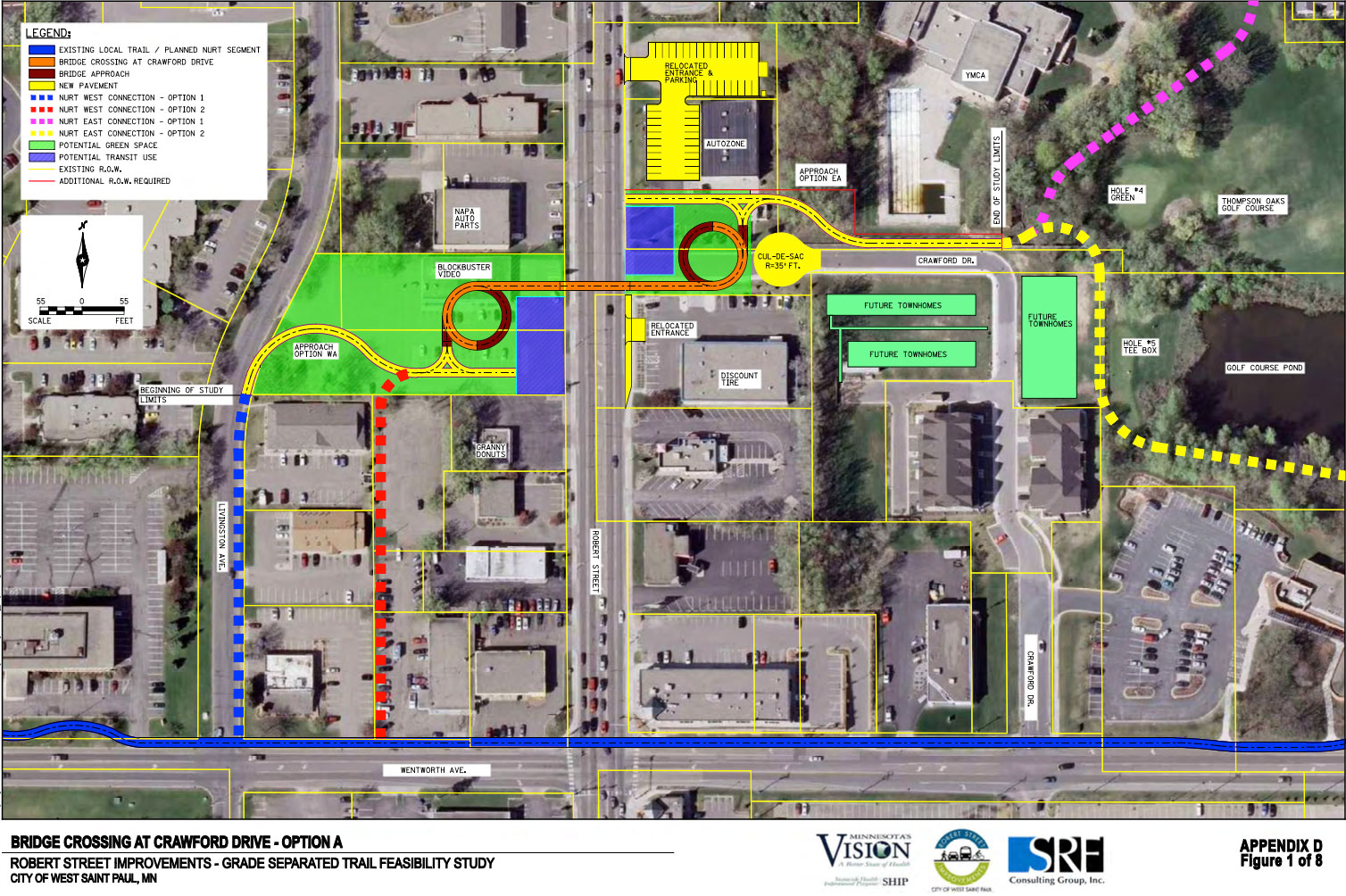
Didn’t the feasibility study recommend a bridge? Yes, what about that 2011 feasibility study? It recommend a bridge over a tunnel for a few reasons (see page 8 of the study):
- Bridge construction would create less disruption on Robert Street.
- Bridges are more aesthetically pleasing and can create a visible community landmark.
- Complications with connecting back to Robert Street.
- Tunnels create areas that aren’t visible and safety concerns need to be mitigated with lighting.
- Finally, unknowns related to utilities under Robert Street are used to argue against a tunnel, but we’re now very aware of what’s under Robert Street and won’t run into any surprises.
So why are we now pushing a tunnel?
The short answer: The tunnel plan is a compromise intended to cost less and save more land for development.
Most of the bridge options were more expensive than the tunnel options. The tunnel is a cheaper way to go. Plus, the latest tunnel plans (released in December 2016) were designed to have a smaller footprint than the 2011 plans. That means more land is available for development.
So anyone suggesting we should be following the recommendations of the 2011 study wants to spend more money and lose more land for development.
The practical answer on tunnel vs. bridge
The more practical reason for a tunnel instead of a bridge is topography. The crossing is planned at a high point. Land slopes away from Robert Street both to the east and the west.
So a bridge requires not only climbing to Robert Street, but then going even higher to get over Robert Street. That requires a long, incline approach on both sides, often achieved with a switchback or loop that takes up a lot of land (and in most of the designs the loop is too tight and doesn’t meet standards).
A tunnel will have less of an incline and make for a simpler, easier trail experience.
Bridge or tunnel, we just need a crossing
This debate is really a distraction. Whether we do it with a bridge or a tunnel, a regional trail needs a separated crossing of a busy, four-lane road.
If we have the money to pay for a bridge and want to give up the extra land, let’s do it. I’m supporting the tunnel because it seems to be a compromise more people can get behind.
3. Will a tunnel be safe?
I’ve addressed this one before, but let’s look at it again.
West St. Paul Police Chief Bud Shaver has no concerns about tunnel safety. He addressed this in 2015 and pointed to the lack of issues with other tunnels in the area.
Shaver did say graffiti and vandalism might be an issue, but nothing that should derail the project. (Sidebar: I’d love to explore a mural concept in conjunction with the tunnel. Murals are good deterrents to graffiti and can be made graffiti-resistant. Plus, murals are cool. West St. Paul could use more public art.)
The tunnel will be lit at night, like other nearby tunnels.
There are currently no plans to install security cameras in the tunnel, but it’s something the County will evaluate. If security became an issue, the County does have a portable system they could roll out quickly.
During the final design phase, the county does plan to meet with Police Chief Bud Shaver and the County’s Parks & Trails Patrol Supervisor to address any concerns.
In short, everyone wants a safe tunnel and we’re taking the appropriate precautions to ensure that.
4. How will construction impact Robert Street?
After more than two years of construction on Robert Street, we’re all tired of it. So what kind of disruption will tunnel construction cause?
It’s too early in the process for specific construction plans, but more than likely it could be done by closing just two lanes at a time. Traffic would either shift and stay open in both directions, or one direction would close at a time.
The good news is construction should be quick. We’re talking weeks, not months. If weather cooperated and everything lined up, it could be done in as little as two weeks.
Things rarely work out that perfectly, but we’re not talking about tying up Robert Street for months on end. It would be limited to the stretch between Thompson and Wentworth and we might be able to maintain local access.
So it’s not ideal, but we’re talking quick, short-term pain for a huge, long-term gain.
Why didn’t we do this when we tore up Robert Street?
Wouldn’t it have been great to do this all at once? Unfortunately, getting Robert Street redone in 2015 and 2016 was enough of a battle that nearly derailed multiple times. Full funding was never in place for the tunnel until now, and nobody could stomach adding those costs to the already over-budget Robert Street reconstruction project.
It’d be nice if everything lined up perfectly, but it doesn’t always happen that way.
5. What about development?
The biggest pushback on the tunnel seems to be business development. Some people argue that business development should come first. I think we can have both.
There are two potential development opportunities that the tunnel impacts, one on each side of Robert Street. On the west side we have the Town Center I development (including the former Blockbuster site) and on the east side we have the YMCA.
The West Side: Town Center I
I’ve already discussed the Blockbuster property, which is part of the proposed Town Center I development. The original plan was always to include a crossing here, so this isn’t new. The amount of land the tunnel would use has even been scaled back from the original plan.
Plus, Robert Street has a ton of empty commercial space. Losing some of that space will only make it easier to fill the remaining vacancies.
The East Side: YMCA
The other potential development is clouded in the unknown because there’s no development plan on the table. The YMCA needs a new facility, but they haven’t decided if they’re going to sell their current location and build a new one somewhere else or simply refurbish or rebuild where they are now. If they do decide to sell, it’s possible a new developer would come in (and acquire Mister Car Wash, Autozone and Abra Auto Body & Glass?) and pitch a large project. The trail and tunnel would use the right of way on the edge of this property, so it’s still unclear how it would impact any potential development deal.

Trail & Development Can Work Together
I think this is a huge opportunity to have a regional trail next to new developments. I’ve said before that the Midtown Greenway spurred $200 million in development, and we could see a similar (though obviously not as large) benefit here.
I’ve said all along that trails and development can work together.
They can work together, but that doesn’t mean they will. As a city, it depends on what we want.
It’s possible a developer will come in and refuse to accommodate a trail. They won’t care about the benefits and won’t adjust their plans. They could bully the city to accept their terms or nothing.
It’s also possible a developer will come in who recognizes the value a regional trail brings. They’ll tweak their plans and find a way to accommodate the trail (Dakota County is even willing to help a developer make it work).
So it either comes down to getting lucky with the right developer or the city could insist on making the trail work and waiting for the right solution. That may mean we have to choose between a development or a trail—saying no to a developer who refuses to work with a trail, and hope another developer comes along.
Personally, I think if we’re going to invest taxpayer money in developments, we should have development that fits our vision for West St. Paul.
Besides, do we really want to welcome an inflexible developer into West St. Paul who refuses to work with what residents want?
Trails and development can work together if we want them to.
6. Can the River-to-River Greenway cross Robert Street anywhere else?
With all the debate over crossing Robert Street, some people have asked if there’s a plan B. Can we put the crossing somewhere else?
Well, not really.
The current site was chosen because it minimizes land acquisition, right of way and easements. For all the debate we’re having about this location, it would be worse anywhere else.
The other reality is that the River-to-River Greenway goes on a diagonal through West St. Paul, connecting a majority of our green spaces and existing trails. Crossing anywhere else would mean losing those connections or creating a massive detour and new trails.
The current crossing of Robert Street at Crawford Drive is the most efficient and economical option.

7. What happens when the trail crosses Wentworth Avenue?
At some point the River-to-River Greenway trail will cross Wentworth Avenue and continue into Marthaler Park. Some critics point out that we’ll have another dangerous crossing.
However, there are a couple plans in place that give us an opportunity to address the crossing at Wentworth. Currently the city is exploring plans to improve the trail through Marthaler Park and has plans in the CIP to improve Wentworth Avenue from Delaware to Livingstone in 2019, including trails.

Between those two projects a safe crossing for Wentworth will be addressed. There are several solutions. It’s possible an existing intersection could be changed to a four-way stop (Humboldt or Livingstone) and the trail could cross there. Another solution is to have a mid-block crossing with pedestrian-activated flashing lights.
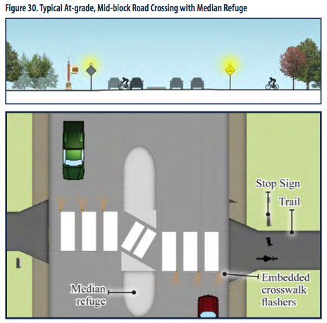
Often these projects have to happen incrementally. In 2015, the Charlton tunnel went in and was only a partial component of the full trail. The Wentworth crossing is another component that will come in the very near future. These things happen one piece at a time, and nobody is going to leave a trail that suddenly abandons people to an unsafe crossing.
8. Will the trail really see 140,000 people?
Dakota County’s 2016 Robert Street Crossing Summary says:
“By 2030 it is anticipated the River to River Greenway will see more than 140,000 regional visitors annually.”
They explain how they came up with this number on page 5, noting it’s a conservative estimate and pointing to similar use on other regional trails.
The County’s 2015 Greenway Master Plan (page 10) says:
“The River to River Greenway Trail, if opened today, could expect approximately 123,000 annual visits.”
Some people have questioned those numbers, and I’ve probably contributed to that by not being exact in my language.
The county uses a standard methodology and it’s an aggregate count that looks at the entire trail and counts average use. If I use the trail every day, I get counted every day.
So we will not see 140,000 separate people using the trail.
But we will see a lot of people use the trail. That’s the point.
A 2013 Met Council report estimated that 20,300 visits were made to the River-to-River Greenway trail’s precursor, the North Urban Regional Trail, in 2012. That’s people using an incomplete trail.
Based on the trails’s projections, finishing the Greenway with the Robert Street tunnel would see a nearly 7-fold increase in usage.
We can quibble over the numbers, and I apologize if I’ve been misleading, but the fact is the trail will get used by a lot of people. That’s probably the thing to focus on: There is serious demand for trails (as seen in the 2017 city survey).
9. Why do we say WSP Greenway?
So I’m part of a group of residents supporting the River-to-River Greenway, and we call our group the WSP Greenway Project.
People on both sides have pointed out that this is a Dakota County project and we shouldn’t call it the West St. Paul Greenway.
Sure.
And we don’t. I’m careful to always call the trail the River-to-River Greenway. But we call our group WSP Greenway for several reasons:
- We’re a group of West St. Paul residents.
- The trail goes right through the heart of West St. Paul.
- While Dakota County is spearheading the current effort, the idea of crossing Robert Street originates with West St. Paul. The basic idea goes back to 2001 and the specific crossing at Crawford Drive is from 2011. Dakota County is just taking up where we left off.
- Mendota Heights and South St. Paul have both done their part to create the River-to-River Greenway, it’s time for West St. Paul to step up.
So yes, the trail itself is not the WSP Greenway, but it can have a great impact on West St. Paul, and I want to claim it as our own.

More Questions
If you have more questions, please ask them. I’ll do my best to answer your questions, and if I don’t know the answer I’ll try to find one.
Some people have said I’m skewing information and trying to mislead people. The reality is I’m excited about this project and I’m sharing as many details as I can. The more I dig into this project, the more I think it’s a good move for West St. Paul.
If there’s an argument against the River-to-River Greenway, I want to hear it. Let’s have an open conversation about this project, hear all the arguments and responses, and make an informed decision about what we want as residents.
How Can You Support It?
If you’re ready to support the River-to-River Greenway, first of all, thanks! We need community support to make this project happen.
Here are two ways to show your support:
More on the River-to-River Greenway:
- Visit Dakota County’s River-to-River Greenway page for project reports, factsheets, and more. Go directly to the source!
- Like the WSP Greenway Project page on Facebook for more details and updates.
- Read my post, How to Make West St. Paul Awesome, for a more positive take on the benefits of the trail.
- Read my post, 7 Misconceptions About the Robert Street Tunnel, for more questions and critiques.
Your writing is replete with myths, conjecture and fluff. You should be writing for the MPLS communist publication. No to more bikeways, paths, lanes, signage and such other waste of taxpayer funds.
Where is my myth, conjecture and fluff? I’ve linked to my sources, I’ve explained my reasoning. I don’t see you doing that. Speaking of sources, here’s a brand new study touting the benefits of cycling and showing that it’s definitely not a waste of taxpayer money.